Last fall, the running world was in awe of Kilian Jornet’s 2025 States of Elevation Project. It was astounding in the sheer distance and elevation he covered over the course of 31 days, as he summited 72 of the 14,000-plus-foot (4,267 meters) peaks (14ers) in the lower 48 states of the U.S.
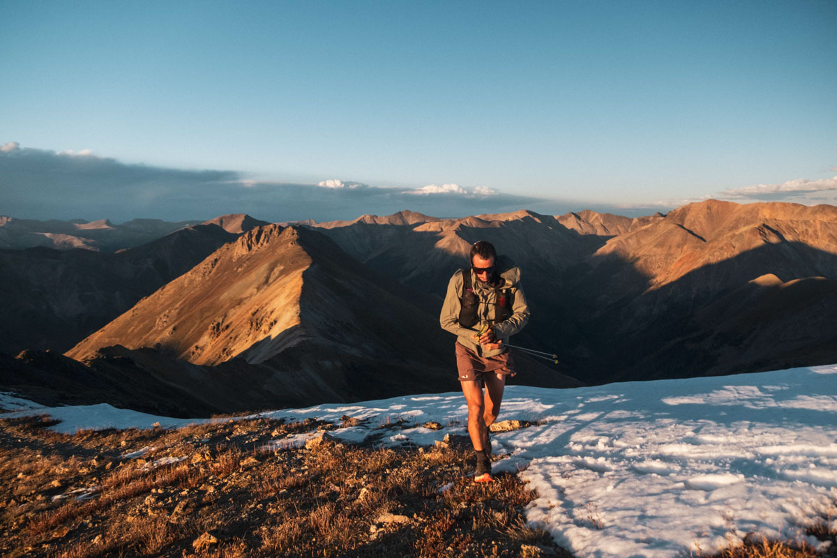
Kilian Jornet tops out Handies Peak in Colorado during his 2025 States of Elevation project. Photo: Nick Danielson
While the distance and elevation of his trip are difficult to comprehend on a human level, what is equally fascinating is the variety of terrain he traversed as he moved through Colorado, Utah, Arizona, Nevada, California, Oregon, and Washington. He passed through several national parks, many mountain ranges, two distinct deserts, endless forests, and a huge number of ecosystems, from desert to alpine. Jornet’s project can be seen through the lens of distance, elevation, and the capabilities of the human body, or as an exploration — and celebration — of the terrain of the American West.
In this article, we’ll dive into some maps and explore the unique geography of the lower 48 states in more detail, framed through Jornet’s States of Elevation project. The 3.12 million square miles (8.08 million square kilometers) of the lower 48 are home to a wide range of different ecosystems, biomes, and geographical features. The area’s massive size, significant longitudinal span, and varied topography lend themselves to a plethora of geographies, as shown in the Geological Society of America map below.
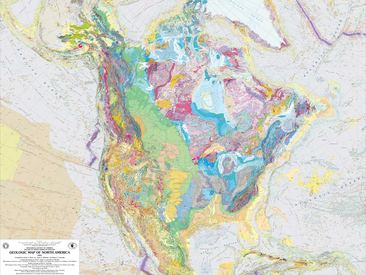
A geologic map of the U.S., Canada, and Mexico. Photo: Geological Society of America. Public domain via Wikimedia Commons.
States of Elevation Overview
Jornet’s well-publicized States of Elevation project in 2025 was a feat in human endurance, mountain running, and planning. Starting on September 3, he linked 72 of the 14ers in the contiguous U.S in a human-powered fashion — on foot and bike — with a support crew following him and helping with logistics. He started with the 14,259-foot Longs Peak in Colorado, then went on to California and north to Washington, finishing on the 14,410-foot Mount Rainier. He did this over 31 days, an incredible display of physical and mental fortitude. According to his watch, he was in motion for nearly 489 hours over this month-long span, which is almost 16 hours per day! Jornet covered 3,197 miles (5,145 kilometers) and climbed 403,690 feet (123,045 meters). He summited all but two of the 14ers in the U.S.’s lower 48 states, skipping two located on private land in Colorado.
Kilian Jornet’s States of Elevation route, from Colorado to Washington. Photo courtesy of NNormal.
Instead of writing in detail about all the stats involved in this project — which has been done several times — this article looks at what inspired Jornet to take on this project: the landscape.
Jornet said, “It’s about exploring the American West, the vastness of the terrain and the cultures that have lived and continue to live there, as well as a nature that is often wild and incredibly diverse, ranging from alpine areas to dense forests and deserts. I am excited to explore these new places.”
Through maps and Jornet’s project, we’ll explore the lower 48 and celebrate the wild, diverse, and awe-inspiring nature found in the contiguous U.S.
The 14ers
A 14er is defined as a mountain peak that rises to at least 14,000 feet above sea level. There is some debate over what constitutes a unique peak in terms of prominence relative to its neighbors, but we will go with the numbers Jornet used.

Meghan Hicks of iRunFar descends La Plata Peak, a 14er in the Sawatch Range, during her 2020 Nolan’s 14 fastest known time. Photo: iRunFar/Eszter Horanyi
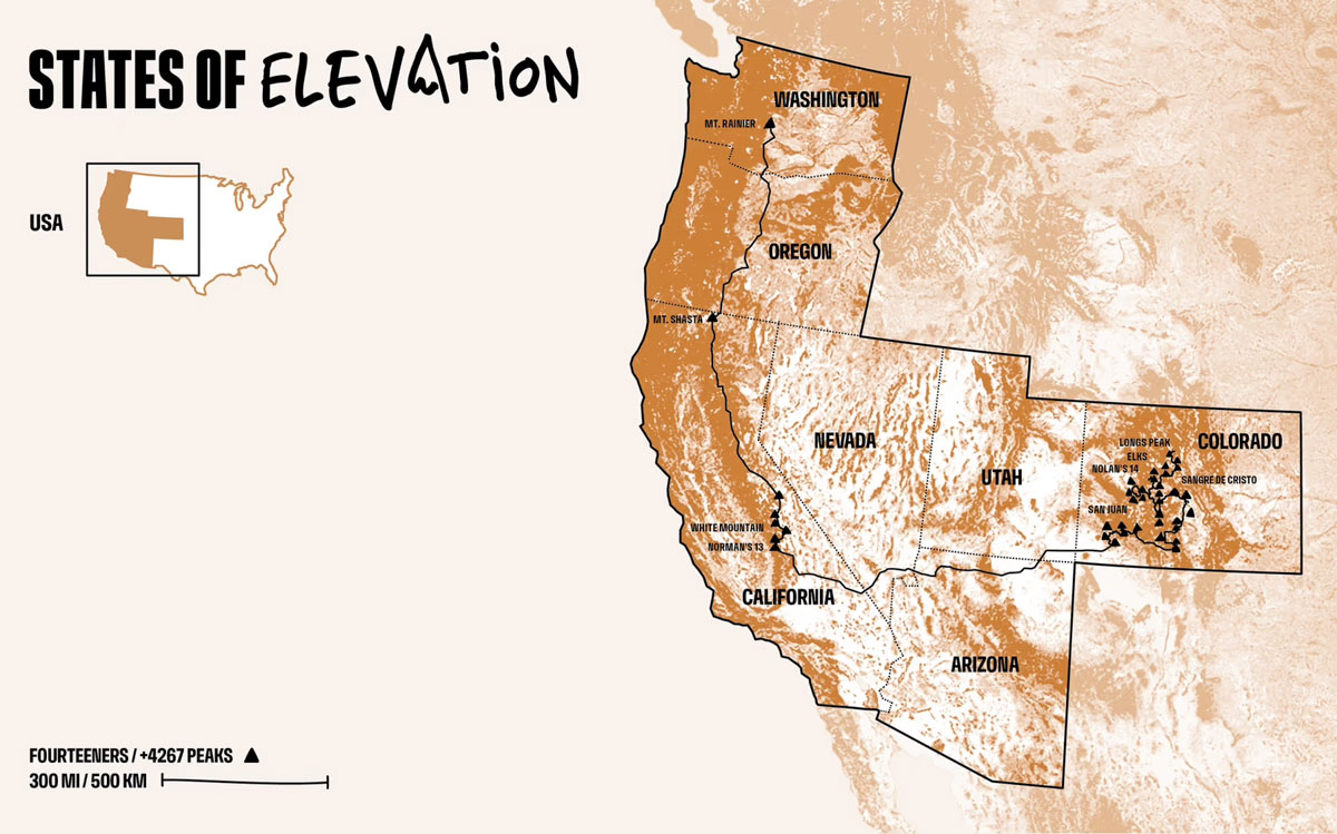
Of the 14ers on public land in the contiguous U.S., 56 are in Colorado, 15 are in California, and one is in Washington. The majority of these mountains are found in the Rocky Mountains of Colorado, with several large clusters in the Sawatch — home of the Nolan’s 14 route — San Juan, Elk, and Sangre de Cristo mountain ranges. In California, there are 13 peaks clustered in the Eastern Sierra, with the traverse between them called the Norman’s 13 route. Additionally, there is White Mountain Peak in the White Mountains of the Inyo National Forest, and Mount Shasta further north in the Cascade Range. Mount Rainier, the one peak in Washington, is also part of the Cascades, which stretch from Northern California across Oregon and into Washington and British Columbia, Canada.
Elevations of the U.S.
Looking beyond individual peaks, there are several major mountain ranges in the U.S. The largest ones are the Appalachian Mountains in the east, the Rocky Mountains stretching from Montana to New Mexico, and the Sierra Nevada and Cascade ranges near the West Coast. Each range has notable long trails running through it: the Appalachian Trail, Continental Divide Trail, and Pacific Crest Trail, respectively. Ultrarunners have taken to fastest known time (FKT) efforts on these premier trails, with runs such as Tara Dower’s 2024 overall supported FKT on the Appalachian Trail and Karel Sabbe’s 2023 men’s supported FKT on the PCT celebrated in the trail running and ultrarunning communities.
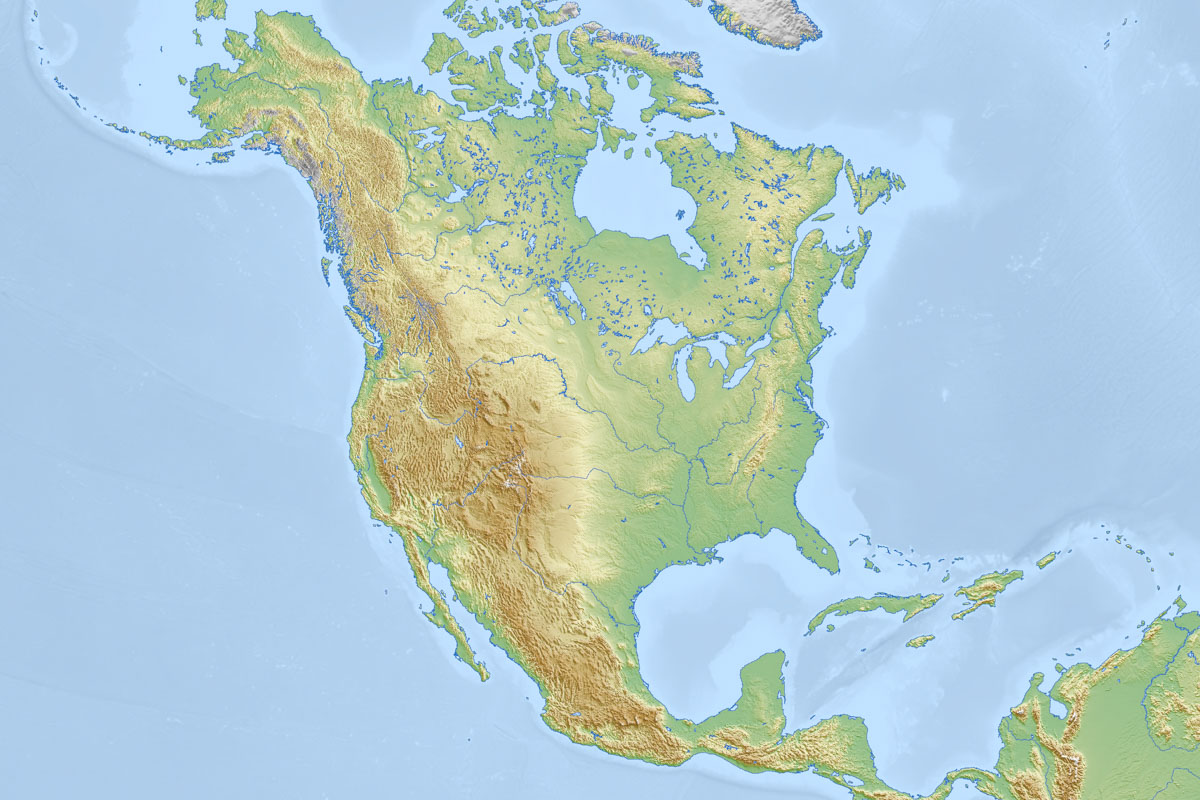
Most of the mountains in the U.S. exist in the western portion of the country. Photo: Mapswire, CC BY 4.0 <https://creativecommons.org/licenses/by/4.0>, via Wikimedia Commons
An elevation map of the U.S. shows that the higher-elevation regions are in the western half of the United States. Luckily for Jornet, there are no 14ers in the east — otherwise he would have had a very long cross-country ride to get between them! Aside from the major ranges, there are several other smaller ranges throughout the country, including the Ouachita and Ozark Mountains in Arkansas, the Iron Range of Minnesota, and others.
National Parks
Jornet’s States of Elevation Project started and ended in national parks. Longs Peak is located in Rocky Mountain National Park in Colorado, and Mount Rainier is within Mount Rainier National Park in Washington. He also passed by or through Mesa Verde National Park in Colorado, Grand Canyon National Park in Arizona, and Yosemite, Sequoia, and Kings Canyon National Parks in California.
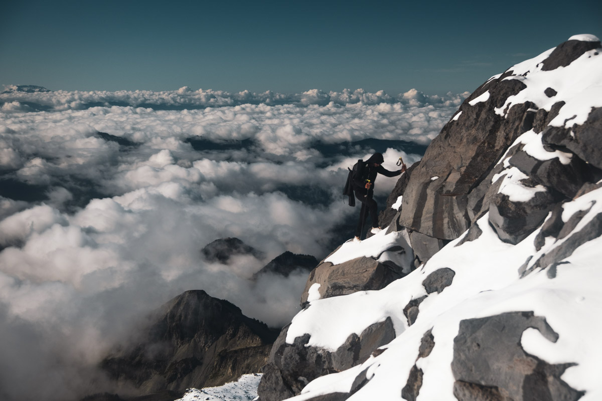
Jornet climbs Mount Rainier in Washington, the final peak of his States of Elevation Project, in Mount Rainier National Park. Photo: Nick Danielson
The National Park Service was established to conserve and protect unique natural landscapes, and the parks encompass some of the most stunning scenery and natural wonders in the area. Yellowstone National Park, established in 1872, was the first park created by U.S. President Ulysses S. Grant. At the time, it protected more than two million acres of land.
The National Park Service currently comprises 63 parks. Of these, 51 are in the lower 48 states. The states with the highest number of parks are California (9), Alaska (8), Utah (5), and Colorado (4). The landscapes in these parks range from desert to high plain to cavernous canyons to rainforests.
In addition to the national parks, the National Park Service also has jurisdiction over national monuments, national historic sites, national rivers, national recreation sites, and more.
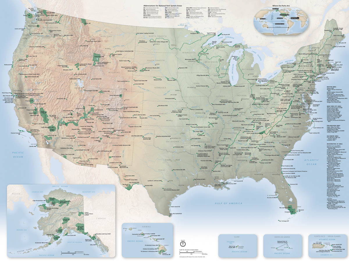
The U.S. National Park Service’s units, including national parks, monuments, scenic trails, historic sites, and more. Photo: U.S. National Park Service
[Editor’s Note: To see a larger version of the above map, please visit the National Park Service website here.]
Ecosystems and Landscapes
Given the latitudinal and elevational differences across the U.S., the landscapes from state to state — and even within states — can differ significantly. Throughout his journey, Jornet traveled from high alpine peaks with minimal vegetation to deep forests teeming with life to vast deserts where only the most drought-resistant plants thrive.
Across the lower 48, there are endless types of ecosystems, from the coniferous forests of the East Coast to the Great Plains in the Midwest to the high desert of Colorado and Utah to the stereotypical cactus-studded deserts of the Southwest to the evergreen forests of the Pacific Northwest. Each ecosystem has its unique plant and animal life, specifically adapted to the conditions at hand.
Deserts
One of the notable features of Jornet’s States of Elevation was that he rode his bike between the peaks. The first extended commute was between the Colorado peaks and those of California’s Sierra Nevada. To cross this distance, Jornet rode from Colorado, through a bit of southern Utah, northern Arizona, and the southern tip of Nevada before arriving in California. On his ride, he passed through parts of both the Great Basin Desert in Utah and Arizona, and the Mojave Desert in Nevada.
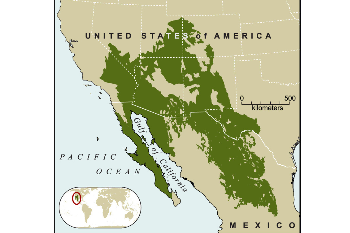
The deserts of the U.S. Southwest. Photo: ConservationIntl, CC BY-SA 4.0 <https://creativecommons.org/licenses/by-sa/4.0>, via Wikimedia Commons
The four main desert ecosystems in North America — which also include the Sonoran and Chihuahuan Deserts further south — are characterized by their low precipitation, creating environments where plants and animals have adapted to the dry conditions. Deserts may primarily be known for their heat, but all but the Sonoran Desert have cold winters, with freezing temperatures during the winter months further limiting plant and animal life. The Sonoran Desert has a warmer subtropical climate than the others, allowing succulents to thrive.
While Jornet benefited from the modern conveniences of having a support crew supplying him with water during the long stretches across the desert, the animals and plants that call these regions home have learned to do without easy access to water.

Jornet gets aero while riding across the desert between Colorado and California. Photo: Nick Danielson
Forests
Forests are the quintessential wild places in the U.S., and about a third of the landmass of the lower 48 states is covered in them. Many of the regions Jornet traveled through in Colorado are forests, and much of his journey through California, Oregon, and Washington was in forests. Animals, insects, and plants of all kinds inhabit and thrive in these lands.
Forested areas can be primarily categorized into three groupings. Deciduous forests, found throughout the eastern U.S., are famous for their fall colors, with oaks, maples, and hickories. Coniferous forests are home to massive Douglas firs, and the coastal area between central California and southern Oregon is known for its redwoods. Temperate rainforests are high-precipitation zones in Southeast Alaska and the Pacific Northwest.
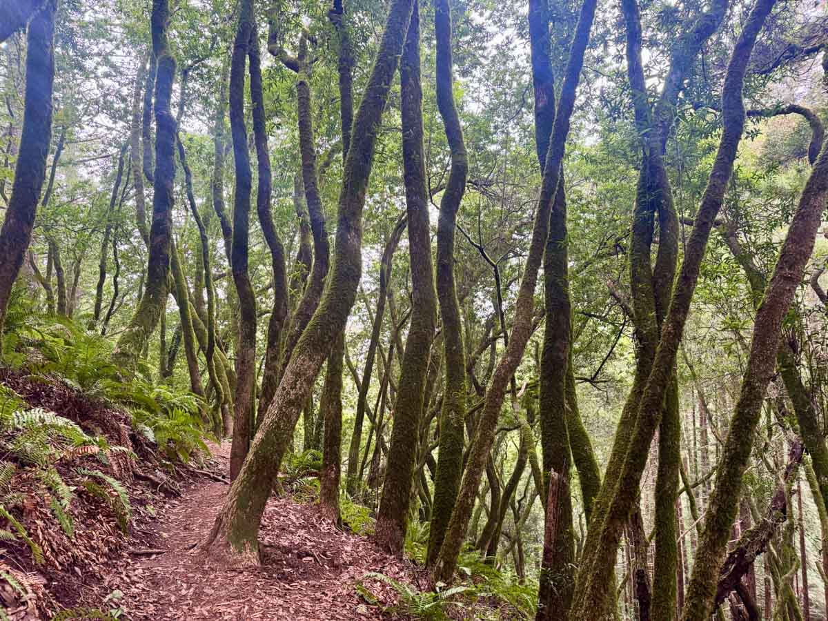
Trees in the temperate rainforests of the U.S.’s Pacific Northwest. Photo: Zander Chase
North America is home to the largest temperate rainforest in the world, which stretches from Northern California to Alaska on the West Coast. The Pacific temperate rainforests have moderate climates between 50 and 75 degrees Fahrenheit (10 to 24 degrees Celsius), and some areas receive more than 10 feet (3.3 meters) of annual precipitation. The lush forests on the Olympic Peninsula in the Quinault, Queets, Hoh, and Bogachiel valleys are spectacular examples of primeval temperate rain forests in the lower 48 states.
In total, there are 154 individual national forest areas in the U.S., and the U.S. Forest Service manages more than 193 million acres.
Spirit of Exploration
The U.S. is home to some of the most incredible wild places in the world, and a trip doesn’t need to be near the magnitude of Jornet’s States of Elevation in order to explore them. For many people, there’s a forest, mountain, desert, or national park nearby that holds countless treasures and special places. Exploring these landscapes on foot is a magical way to get to know them. Whether it’s through a self-supported adventure or a trail race, there is so much to see.
For me, the exploration spark truly started while living in Washington state. I realized that backpacking was a great way to experience the North Cascades, the Olympic Peninsula, the Hoh Rain Forest, the Wonderland Trail, and so much more. Discovering running just made it easier and faster.
Regardless of where you live, running can be a mechanism to see the variety of geographical features, from the Green Mountains of Vermont to the dramatic canyons in Zion to the redwoods of the California coast. It’s a big world out there, and I’m excited to hear where both Kilian Jornet and all of you will be exploring next.

iRunFar’s Meghan Hicks fastpacking in a cold Utah canyon in the Great Basin Desert. Photo: iRunFar/Eszter Horanyi
Call for Comments
- What is the most unique geography you’ve run in?
- What geographical landmark are you most intrigued by?
- Where will you visit next?
