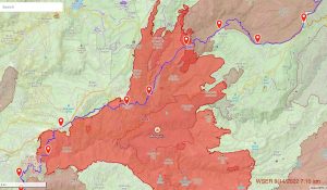
Western States 100 fire map – September 14

A map showing the area of the spread of the Mosquito Fire relative to the Western States Trail, as of Wednesday, September 14, 2022. The Western States Trail is the blue line, the largest area of red shading is the perimeter of the Mosquito Fire, the lightest red shading is the perimeter of the 2013 American Fire, and the darkest red shading is where the two fire boundaries now overlap. The Western States 100 travels on the Western States Trail from east to west, or from right to left in this graphic. Image courtesy of Craig Thornley/Western States 100.
By on | Comments

Western States 100 fire map - September 14

Meghan Hicks

Meghan Hicks is the Editor-in-Chief of iRunFar. She’s been running since she was 13 years old, and writing and editing about the sport for more than 15 years. She served as iRunFar’s Managing Editor from 2013 through mid-2023, when she stepped into the role of Editor-in-Chief. Aside from iRunFar, Meghan is the Board President of the Hardrock Hundred Endurance Run, has worked in communications and education in several of America’s national parks, was a contributing editor for Trail Runner magazine, and served as a columnist at Marathon & Beyond. She’s the co-author of Where the Road Ends: A Guide to Trail Running with Bryon Powell. She won the 2013 Marathon des Sables, finished on the podium of the Hardrock 100 Mile in 2021, and has previously set fastest known times on the Nolan’s 14 mountain running route in 2016 and 2020. Based part-time in Moab, Utah and Silverton, Colorado, Meghan also enjoys reading, biking, backpacking, and watching sunsets.