![]() [Editor’s Note: Remember when contributor Reese Ruland announced that she was taking iRunFar’s Destination Dirt series on the road this summer and wanted your input on where to go? Well, she traveled the country and had a great time running trails as she did. In her first installment, Reese divulges some secrets from the best trail running to be done around Lake City, Colorado, home of the San Juan Solstice 50, smack in the middle of the sick San Juan Mountains, and not far off the Hardrock 100 course.]
[Editor’s Note: Remember when contributor Reese Ruland announced that she was taking iRunFar’s Destination Dirt series on the road this summer and wanted your input on where to go? Well, she traveled the country and had a great time running trails as she did. In her first installment, Reese divulges some secrets from the best trail running to be done around Lake City, Colorado, home of the San Juan Solstice 50, smack in the middle of the sick San Juan Mountains, and not far off the Hardrock 100 course.]
You see, I thought I was being very clever by starting my personal Pro Leisure Tour (PLT) exactly where I ended it last year, in Lake City, Colorado. Start where I’d left off! I planned to go there, scout out a few trails, tag some 14ers, eat some ice cream, and write about it for iRunFar. Once I arrived to the small town, situated snugly between steep hills, I realized my plans would soon be changing.
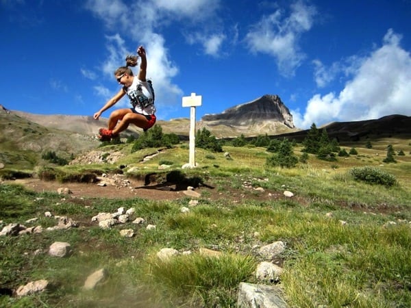
The author on Uncompaghre. All photos courtesy of Reese Ruland.
You see, my training was in its beginning stages. I had not run consistently for nearly a year and I was just coming off of a two-month rest period. It’s true that I had been running here and there in Boulder, but I knew that I needed to curb my enthusiasm by slowly easing back into running so as not to injure myself. Nothing too crazy, long, or difficult. There was one glaring problem with this theory: I had placed myself in the San Juans.
Being there in the mecca of mountains, the cream of the crop, the top of the tier, was entirely too overwhelming for me. I needed to be out in the mountains! So, after considerable consideration, I decided to do what any rational person would do: sign up for one of the toughest 50-mile races, the San Juan Solstice, the night before the race. Why not? I had some time to kill and it’s a great way to investigate the trails and the people who run them.
While the race itself was pretty great, considering how bad it could have been given my state of training, I think I was most impressed with how supportive everyone was of the race. Not just people directly involved, but the entire town of Lake City. The local businesses chipped in awards for runners, cafes opened up early so crews and runners could have coffee at an ungodly hour, volunteers from town staffed the aid stations, and spectators cheered for the disheveled runners as they finished through town. It was refreshing to see an entire community stand behind a grassroots event that showcases some of Colorado’s most beautiful landscape.
I set out on a mission this summer to see if the trails or the town was what made the trail scene so great and, after spending a decent amount of time in Lake City, it is clear that there’s a wonderful balance of having great trails and a great town. Below I’ve tried to briefly describe some trails, but it’s difficult to capture how spectacular this area is. It’s definitely worth a visit and I’m certainly glad it’s where I started this year’s PLT.
Easy Trail Run
Given the city’s spectacular location, it’s pretty difficult to find an easy trail in Lake City. I thought of making Pete’s Landing Trail the easy trail run, but considering it is a buffed-out loop that circumnavigates a very tiny pond, I decided to up my standards. Please keep that in mind that an easy Lake City trail might be considered a hard trail in a different location.
Cooper Creek Trail – This little out-and-back leads runners to a secluded glacial valley containing Cooper Lake. The trail is located off of the road to Lake San Cristobal and you can access it with any kind of vehicle. Take that road for a roughly 12 miles before you’ll bear right at the fork. (The road changes to dirt about four miles in.) From there, keep driving! It’s nearly 4.5 miles to the Silver Creek Trail. From there, the start of the hike is still one mile further on the right. The long drive is worth the just-shy-of-four-miles, one-way hike. While you’ll need to cross through the chilly water a few times, the creek offers a guiding light if you should ever question the trail. The trail follows the creek to the lake. Once you reach the lake you can stay there or bushwhack your way on an undefined trail to Lee Smelter Gulch. If you take that route, your day just became a little less easy. From Cooper Lake, return the way you came for about 7.5 miles of fun. (trailhead location map, topographic map)
Moderate Trail Runs
Alpine Gulch Trail – This trail may be familiar to those who have run the San Juan Solstice 50 as it is the first real trail section of the course. It is located on the left side of the Alpine Loop Scenic Byway. Parking will be on the right. Drive to this trailhead with any vehicle you like. The trail crosses a well-made bridge and gradually climbs as it switches back and forth across a stream several times. Don’t worry, log bridges are there to help if wet shoes are a concern. At the first trail intersection, runners should head up the East Fork Trail, to the left. This fork is about 2.5 miles uphill from the trailhead. From here, the trail begins to really climb. You will eventually broach treeline after another 3.5 miles. Views of the surrounding 14ers are spectacular! Some might want to continue up up the trail to higher elevation. After treeline, I think it’s worth it to explore the trail at your own speed and for as long as weather/energy levels permit. If you want a different route, start at the same trailhead, but take a right at the trail junction toward West Fork Trail. There are campsites along the trail for those interested in backcountry camping. The outing to treeline and return is about 12 miles total. (trailhead location map, topographic map)

Crossing the bridge right after the Alpline Gulch trailhead.
Wager Gulch Trail – The San Juan Solstice uses some great trails on their course, which is why I’m also recommending another one. This trail is actually a rough, 4×4 road. If you don’t have 4×4 transport, begin your run at the trailhead, located on the left, four miles down the road to Lake San Cristobal. From there, it’s 3.7 miles to the Carson town site, a stellar ‘ghost town’. If you’ve got 4×4 wheels, drive into the Carson town site and begin your run there. From the Carson town site, runners can see several trails along the hillside. I recommend staying on the main jeep road until it reaches the saddle after 1.4 miles. From there you can hook up with the Colorado Trail and the Continental Divide. Essentially, this is a great starting point for a chose-your-own adventure day. (trailhead location map, topographic map)

Wager Gulch trailhead, looking down towards Carson town site from the saddle.
Advanced Trail Runs
Uncompaghre Peak – While there are several difficult trails to choose from in Lake City, my personal favorite is the route to Uncompaghre, one of Colorado’s 14ers. It’s a difficult trailhead to reach, but once you get there, the climb up to the summit is spectacular. Drive up the Alpine Loop Scenic Byway for five miles until you see the Nellie Creek Trailhead on the right. If you are in a low-clearance vehicle, park your car at one of the pullouts and walk the last four miles to the trailhead. If you have the proper 4×4 vehicle, drive on up.
From the 4×4 trailhead, the roundtrip distance to the summit is just over seven miles. Starting out, you’ll quickly rise above treeline and the peak will be directly in front of you. The trail winds back and forth in front of the peak. Eventually, the trail climbs to the left side of the peak up a ridgeline. The trail will become steep and rocky for a short while, but it gradually gets easier. Cairns mark the trail through the rocky section. Continue on this trail as it quickly ascends to the summit. The summit itself is very large and affords wonderful views of surrounding peaks. Enjoy your time at altitude before descending back down the same route. (Uncompaghre 14ers.com page)

More Uncompaghre.
Redcloud and Sunshine Peaks – These two 14ers are fairly easy to tag together if you start early in the day. I’d recommend camping nearby as it’s a long, slow, 16-mile drive to reach the trailhead. To get to the Silver Creek Trail, head toward Cinnamon Pass on CR30, the road to Lake San Cristobal. When the road splits near 12 miles, stay to the right. The trailhead will be on your right. You can get there with a two-wheel drive vehicle, going slowly.

On the way up to Redcloud.
From the parking area, head northeast toward the trees. The trail is nestled in between red rocks and Silver Creek for a while before the basin opens up and the trail becomes more obvious. The trail will zigzag through this basin, but will eventually head toward the right to gain the ridge. At the saddle, turn right and head up the steep ridge to Redcloud’s summit. From the summit of Redcloud, you can see the summit of Sunshine. To get there, continue straight down the other side of the peak. You’ll see a trail along the ridgeline. At the saddle between the two peaks, continue straight up to Sunshine. The distance between the two doesn’t look too far, but it is further than you think, especially because you have to come all the way back over Redcloud to descend to the trailhead. Be aware of afternoon weather fronts! (trailhead location map, topographic map)

From the Redcloud summit, looking at the Sunshine hike.
Absurd Things for Absurd People
These are ideas that I have done, have seen my friends do, or have contemplated doing.
The Cinnamon Horse – You can thank Brendan Trimboli for this gem. Start in Silverton; leave your car there. Bike or run up over Cinnamon Pass on the Alpine Scenic Byway, the famous 4×4 vehicle road. Descend into Lake City. It’s roughly 40 miles. If you start the same time as a vehicle, try to beat it.
Town Park, Alpine Gulch, Williams Creek, Town Park loop – This is pretty silly, but begin in Lake City’s Town Park and head up toward Engineer Pass on the Alpine Scenic Byway. Turn left down the Alpine Gulch Trail (described above). Follow this for 13.2 miles. End at Williams Creek Campground. Turn left on the road, which is CR 30, the road to Lake San Cristobal. Head back to town. (This would be a great place to stash a bike the night before if you don’t enjoy road running.) You’ll pass Lake San Cristobal on your right. When the road Ts into another road, take a left. You’ll run two miles, mostly downhill, back to town. Get ice cream at the San Juan Soda Company.
Notable Places
Lake San Cristobal – Located a few miles away from downtown on CR 30, this 340-acre lake is the second-largest natural lake in Colorado. While it is a great place to camp and fish, runners might enjoy taking a cold dip in the water!

Lake San Cristobal.
Mean Jean’s Internet Coffee Shop – Located on Gunnison Avenue, this cafe is a hot spot for all those who just finished a big climb and need to refuel, recaffeinate, and upload photos to Facebook. The owner, Hannah Jean, is usually working behind the counter, serving her guests delicious concoctions. The prices are great; the Internet is fast; and the atmosphere inviting. If you stop in on a Friday evening, you’ll be able to tap your feet to some live music.
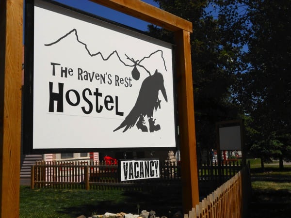
Raven’s Rest Hostel – If camping in your truck or roughing it in a tent has become old, stop into this hostel for some fine accommodations. Located right next to Mean Jean’s, it’s a dirtbag’s dream spot. Showers. Roof. Beds. Inexpensive rates. Cafe with Internet next door. What more could you want?
San Juan Soda Company – The gifts and trinkets are nice, but the ice cream is better. Located across from Town Park, this shop is home to some tasty treats. After running around in the mountains, a waffle cone stuffed with rich ice cream is sure to satisfy any sugar craving.

Call for Comments (from Meghan)
- Have you run around Lake City? If so, what other trail gems have you found?
- And, can you add any beta to the ‘Notable Places’ list for Lake City? Where should one eat, drink, and hang out when not on the trails?
