![]() [Editor’s Note: Here’s Reese Ruland’s second Destination Dirt installment from last summer when she took iRunFar’s Destination Dirt series to the road. Her first article was from Lake City, Colorado.]
[Editor’s Note: Here’s Reese Ruland’s second Destination Dirt installment from last summer when she took iRunFar’s Destination Dirt series to the road. Her first article was from Lake City, Colorado.]
Nestled in the western panhandle of the state amongst the Appalachian Valley and the Potomac River sits the small town of Williamsport, Maryland, commonly referred to as “Dub Port” by locals. How would I know what the locals call this rural community? Because I used to be a local. Williamsport is where it all started for me, running-wise, that is. Participating in cross country, indoor, and outdoor track sparked the fire, but what really ignited it was volunteering at the JFK 50 Mile’s 42-mile aid station all through high school. You see, the JFK 50 finishes about two minutes from my house and my cross-country coach was that aid station’s captain. To top it off, each year, JFK 50 hopefuls could be seen running along the canal near my high school, logging miles and building their endurance. Avoiding the JFK 50 wasn’t an option.
Not that I ever tried to avoid it. In fact, it was my first ultra. It was decided that I, along with my best friend, were going to run the JFK 50 together after we graduated high school. So we trained (which looking back, I never really trained well for it) and pretty much just dove right in. I’ll spare you all from reading about my first experience running an ultra, but I will say that the experience moved me so deeply that, despite my inability to walk the next few days, I wanted more. I loved the overwhelming sense of accomplishment I felt when we crossed the finish line together. I loved how little groups of runners would trade places every few miles, always chatting as they passed. I wanted to be part of this ultra community, because to this then-19-year old, they were cooler than the kids on my college campus. Having not visited home in nearly three years, I was pretty excited to get back to the trails that my teen angst once took me down. As one might expect, going home simply flooded my mind with fond running memories. Perhaps visiting nostalgia helps cultivate a better appreciation for the things we love. Luckily for all you iRunFar readers, this article isn’t about my sappy memories, but about where to run. Here goes!

Williamsport from the Doubleday Hill Monument in downtown. All photos courtesy of the author.
C&O Canal Towpath from Cushwa Basin
Sitting at the confluence of the Conococheague Creek and the Potomac River, the Cushwa Basin was once a main shipping hub along the Chesapeake & Ohio (C&O) canal, a 184.5-mile long canal and accompanying towpath stretching from Cumberland, Maryland to Washington, D.C. For 100 years, the canal was used to transport coal, lumber, and agriculture products up and down Maryland’s western panhandle. Although the canal was shut down in 1924, the towpath still sees plenty of use from from runners, cyclists, and horseback riders.The Cushwa Basin is situated near the 100th mile of the C&O Canal, so you’ll have plenty of room to run no matter which direction you decide to go. Taking a left at the basin will take you south where you will pass an iron train truss and the lock house. Turn right and you’ll run across the Conococheague Aqueduct. Each direction will take you on a trip down a historical lane, literally and physically. The canal is flat so don’t expect (any) vert numbers for the day, but it offers runners an experience with some of Maryland’s history while gaining fitness. To pass the time, take a crack at spelling ‘Conococheague’ on the run.
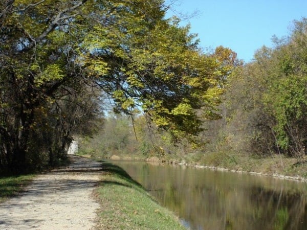
The C&O Canal and Towpath.
Appalachian Trail from South Mountain Inn
The South Mountain Inn is known for a few things:
- Having a fantastic brunch, and
- Being next to the Appalachian Trail.
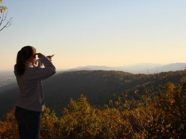
The author on this section of the AT.
The trail is typical for that of the Maryland section of the AT, rocky. Be prepared to fall. Due to the length, you could potentially cover on this trail, say to Maine or Georgia, you might want to make the run an out and back that suits your needs. It is recommended that you park at South Mountain Inn and head south, following the white markers on the trees. If you are looking for a shorter run, head 3.7-ish miles to White Rocks Overlook. If you are feeling like you want to add more distance, continue on the trail a bit more until you reach the side trail for the Bear Spring Cabin. From the turnoff, follow the blue markers on the trees on the trees for a little under a mile to the cabin. From here, return the way you came or, if you are lethargic from the approximately five-mile, one-way journey, spend the night (rental available through Potomac Appalachian Trail Club)! This section of the AT is also run during the JFK 50 Mile, so you’ll see lots of locals training on it.

The AT on South Mountain.
Appalachian Trail to Annapolis Rock
This is another one of my favorite AT runs, mainly because it is an obvious representation of Maryland. The trail starts near the deafening interstate but soon whisks you away into the quiet of the mountains, a swift transition from the harsh reality of Maryland’s suburban sprawl to the pristine solitude of the trail. From the trailhead parking lot, follow the blue blazes until they merge with the white ones of AT. At this point, you will see a bridge spanning Interstate 70. From here you turn north (right) and follow the blazes on the trees. The trail climbs steadily at first, but soon becomes quite rolling and smooth. While it is only a 2.4-mile run one way to Annapolis Rock, it’s well worth the views of the vast valley. I highly recommend a fall trip when the trees mirror the colors of an autumn bouquet. On your return, instead of heading back to the parking lot, you can go across the interstate bridge and stay on the AT for three miles. You will end at Washington Monument, a tower erected in 1827 by the citizens of Boonsboro, Maryland. Return the way you came. Fun fact: it is the first monument dedicated to the memory of George Washington. If you are able to tag both spots, you’ll have landed yourself a nice 10-ish mile run. Bravo!
Antietam National Battlefield

Bloody Lane Trail in Antietam National Battlefield
Nearby in Sharpsburg, Civil War enthusiasts can get their running and historical needs met at Antietam National Battlefield. The area has numerous trails that will take you all through the battlefields’ many memorials. If you are looking for a long, out-and-back trail that features several loops, just keep reading. Starting at the Visitor Center, take the Bloody Lane Trail to the Observation Tower. Definitely go to the top of the tower and get a view of the area. Turn back around on the trail until you meet up with the Three Farms Trail. Turn right and take this trail until you meet up with Sherrick Farm Trail. Take a left on that. The trail crosses a road and meets up with the Union Advance Trail. This is a short, loop trail, so you can go either way. Just make sure to cross over Burnside Bridge when you reach it. Take a left after the bridge and meet up with Snavelys Ford Trail, which is also a loop, so you can turn either direction. This trail connects to the Final Attack Trail in several places. If you are inclined, take one of those connections. The Final Attack Trail is basically a couple loops so it will eventually take you back onto Snavelys Ford Trail. Now, return the way you came, or you can take some roads, as you will surely pass several monuments on your way back to the Visitor Center. Before you go, get a map from the Visitor Center, and you can also look at the digital map on the park’s website, too.
Catoctin Mountain Park
East side
Located in the Monocacy River valley in the Catoctin Mountains, Catoctin Mountain Park offers suburbanites a breath of fresh air from the hustle and bustle of the many metropolis areas that surround it. The park, built up by the Civil Conservation Corps in the 1930s, is divided into two parts, its east and west sides. The east portion of the park can be described as more mellow, while the west offers more technical, rugged terrain. To hop on a trail from the east side, you can choose any trailhead from the Visitor Center, but I highly recommend an 8.5-mile loop that would encompass the park’s most notable features: Cunningham Falls, Chimney Rock, Hog Rock, Blue Ridge Summit Vista, Thurmont Vista, and Wolf Rock. Starting at the Visitor Center, jump on the Falls Nature Trail, which crosses Maryland Route 77 1.1 miles from the Visitor Center. The falls are 1.4 miles from the start. Once you are done snapping photos of the falls, turn around and head toward the Hog Rock Vista Trail, which throws some nice, steep hills your way. Hog Rock Vista Trail drops you out at a parking lot where you pick up your next trail, Blue Ridge Summit Vista Trail. Get on that sucker for nearly a mile. Take that baby to Thurmont Vista. Not that anyone is counting, but 0.6 miles later, you’ll hit Wolf Rock Trail. You got it, take that trail all the way back tot he Visitor Center. Bam, an easy 8.5 miles. Now since you run far, turn around and do it backward. It’s a bit harder too. Here’s a map of the park’s east side and another description of this loop.
West side
The wild west side of the park is for those of you who laugh in the face of danger. Well, not exactly, but considering the east side, it is more rugged. The best way to find out more about this side is to locate Cunningham Falls again on your second lap around the east side and connect with the Catoctin Trail. From there, you’ll see a man in a trench coat smoking a cigar. Tell him the password and he’ll show you how to get to some cool Adirondack Shelters. Or you could bring a map of the park’s west side. One more time, here’s the east-side map to help you find your way over to the west side from Cunningham Falls.
Things to Do When You Aren’t Running
Eat!
Visit Desert Rose Cafe in the pleasant town of Williamsport. Try the wraps. And pastries. It’s located close to the Cushwa Basin, so when you are done with your flat, 50-mile run, stop in for a treat! Running cross country and track in the great town of Williamsport means it is inevitable that I’d be a regular at the only Italian restaurant within walking distance from the high school and my house. Tony’s Pizza Time Cafe is the quintessential hometown pizza parlor and I’m not just saying that because I always ate there and my friends worked there, but those are certainly weighing in on my statement. It has awesome pizza and meatball subs. Go there. I promise you won’t regret it. If you do regret it, just run more.
Visit!
This is odd, but go to the River View Cemetery, only because you can run up to Doubleday Hill Monument. The monument commemorates General Abner Doubleday who used the site to set up a battery of artillery during the Civil War. As an aside, Doubleday supposedly invented the game of baseball in 1835, but I’m not buying it. The hill is worth a gander due to its remarkable view. It’s one of the higher points–physically, not in any abstract way–of town and affords one a great view of the Potomac River, wild West Virginia, and the busy metropolis that is Williamsport.

Canal Days is pretty much the biggest thing that happens in Williamsport. It’s a typical, rural-town festival, complete with tractors, craft tents, and, of course, the strong aroma of funnel cakes, deep-fried Oreos, and fresh-squeezed lemonade. The town picked to host the event in August and it typically occurs on the hottest, most humid day of the year. But not to worry, just jump in the river for a cool down!
High Rock is a little ways away from Williamsport, but worth the drive. You can park at Pen-Mar Park or at the actual rock. If you park at Pen-Mar, check out the AT. If you head north, toward Maine, you’ll be able to stand on the Mason-Dixon line. Pretty awesome, huh?
But if You MUST Run….
Try the iconic JFK 50 Mile or the Hike Across Maryland.
Call for Comments (from Meghan)
- Calling all Williamsport and environs enthusiasts, what say you about your locals trails? Have you another trail run to add to this list? Do share!
- And, how about places to eat and things to do when you’re not running, what would you add to Reese’s list?
