![]() From Salt Lake City proper, the Wasatch Mountains’ profile looks like a toddler’s first attempt at drawing mountains as a landform: snaggled, raggled, sharp-edged peaks that are, in some places, 5,000 vertical feet worth of dinosaur teeth taller than town. The mountains look grumpy and tough, but that edginess beckons us mountain lovers with a come-hither whisper. It is because of all this that Salt Lake City, though sprawled as a grid in a near-flat valley with only the edge of town creeping into the range’s lowest hills, is synonymous with the mountains.
From Salt Lake City proper, the Wasatch Mountains’ profile looks like a toddler’s first attempt at drawing mountains as a landform: snaggled, raggled, sharp-edged peaks that are, in some places, 5,000 vertical feet worth of dinosaur teeth taller than town. The mountains look grumpy and tough, but that edginess beckons us mountain lovers with a come-hither whisper. It is because of all this that Salt Lake City, though sprawled as a grid in a near-flat valley with only the edge of town creeping into the range’s lowest hills, is synonymous with the mountains.
The Wasatch Mountains are prized trail running terrain, and this is no secret. Everyone and their mother takes to the dirt above the city. On a sunshine-y afternoon – well, every day except Sunday as this is a Mormon-dominant town – literal hordes of humans (and their dogs, SLC-ites love their dogs!) populate the trails. And, more than a dozen top trail and ultrarunners call the Wasatch Mountains their home turf, including the Speedgoat and 100-Mile King, Karl Meltzer, Barkley Marathons finisher and off-the-charts mountain athlete Jared Campbell, multi-sport champ and endurance coach Matt Hart, short-distance trail specialist Rachel Cieslewicz, the sweetheart of the Wasatch’s burliest trails, Sarah Evans McCloskey, and many other rad runners.
There’s a boat-load of verticality in the Wasatch, so the vast majority of trail running around SLC involves going very far up and then very far back down. The trails at the edge of town, which may be categorized as urban or well-developed quickly yield to technical and remote trails far removed from the city’s trappings. Stay safe out there by using a bit of caution:
- The Wasatch Mountains below 8,000 feet altitude are rife with rattlesnakes. Mind where you place your feet and hands.
- Summer thunderstorms can add lightning hazards to alpine adventures. If you’re planning to get high, start early and return to treeline if the weather turns.
- The summer climate of SLC is hot and dry. Save your lower-country runs for morning or evening to avoid afternoon highs in the 90s and sometimes 100s Fahrenheit.
- In cold weather, dress appropriately. Many trails are accessible in the shoulder seasons and winter due to the large number of people out and about, tamping down snow on the trails. This is a fantastic aspect of having a trail system adjacent to a metropolitan area, but the downside is that this allows trail runners to get pretty far out in not-always-benign conditions.
- SLC’s dirty not-so-secret are its winter inversions, which occasionally trap cold air and pollutant particles near the Earth, creating unhealthy smog. When the inversion is in full effect, trail running in it is far from fun.
Below, we’ll provide you with examples of easy, moderate, and advanced trail runs in and close to Salt Lake City. After giving you some example runs, we’ll let you know where to hunt down gear and food. We’ll also provide a resources list, where you can learn more about your adventures afoot.
Easy Trail Run – Bonneville Shoreline Trail from the Dry Creek Trailhead
Navigate your way to the Dry Creek Trailhead, which is located at the Jewish Community Center on North Campus Drive. Park in the east side of the community center lot, and look for a narrow gate by the power station. Go through that gate and up the dirt road for less than a quarter mile until you intersect the Bonneville Shoreline Trail (BST). The BST is beautiful in either direction, but the best part of it in or near SLC proper is to the north, a left turn. The trail climbs for a while in Dry Creek Canyon and then, after a tight hairpin, spills back out onto the front of the hills where you’ll garner a sick view. Run as far as you like on the BST before returning to where you started, but a five-mile out-and-back with 600 feet of climb yields great bang for your buck. In the late spring, a run on the BST can gift you with pastures of arrowleaf balsamroot.
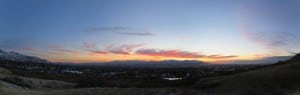
An autumn evening’s view of the Oqhuirr Mountains, SLC, and the Great Salt Lake from further south on the BST. Photo: Bryon Powell (click to enlarge)
Insider’s Scoop:
The BST stretches some 280 miles both way north and south of Salt Lake City and travels mostly on what’s called a topographic bench. This bench was created by ancient Lake Bonneville, which filled all of what’s now Salt Lake City and much more from about 32,000 to 14,500 years ago.
Moderate Trail Run – Grandeur Peak from the Church Fork Trailhead
It’s a little sassy to call a summiting 8299-foot Grandeur Peak, one of the closest, most accessible, and most iconic peaks above Salt Lake City, a moderate trail run because so few folks can actually run the whole dang thing. Okay, you know you want to see how high you can get before you go impossibly anaerobic. Make sure to report back!
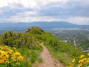
The view from Grandeur in spring. Photo: Meghan Hicks
To access the Church Fork Trailhead, drive up Mill Creek Canyon 3.2 miles to the Church Fork Picnic Area. Park on the roadway and walk a short distance into the picnic area and onto the trail, which is on the north side of the picnic area. Climb roughly 2400 feet in 2 3/4 miles up a series of switchbacks to a saddle and the onto a ridge for the final summit push. Once you’ve had your fill of views of the Wasatch Front, Mill Creek Canyon, and Parley’s Canyon, return the way you came.
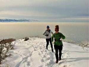
Winter running on Grandeur. Photo: Meghan Hicks
Insider’s Scoop:
The West Ridge Trail is the shorter, steeper sister of the Church Fork Trailhead access to Grandeur Peak. It’s only 4.5 miles roundtrip, but has 3300-ish feet of climb and, get this, not a single switchback. That’ll really clear out the cobwebs, no? Access the West Ridge Trail from the very north end of Wasatch Boulevard just south of Interstate 80.
Advanced Trail Run – Mount Timpanogos from the Timpooneke Trailhead
“They” say that the 11,749-foot Mount Timpanogos is the most popular hiking destination in Utah and I believe it, especially on the summit at about 11 am on a Saturday. But this airy mountain tiptop is absolutely worth sharing, whether it’s with other humans or the herds of mountain goats who love its alpine environment. Access the trailhead by driving up American Fork Canyon and onto the Alpine Loop. Turn right at the Timpooneke Campground and drive a short distance until the road ends at the trailhead.
From here, it’s 7.5 miles and about 4600 feet elevation gain to the summit. On this route, enjoy Scout Falls (about a mile in from the trailhead), above-treeline Timpanogos Basin (and the less-steep trail across it), the Timp Saddle (you’ll know it when you’re hoofing up to it), the Giant Staircase (a slightly exposed couple of switchbacks inside a small couloir), and the old triangulation station on the summit (now mostly a canvas for summit-fever graffiti). Return the way you came when you’ve had your fill of the proverbial top of the world.
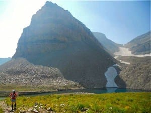
The author and Emerald Lake on Mount Timpanogos. Photo: Vince Heyd
Insider’s Scoop:
The trail is usually accessible for summer-season assaults from the beginning of July until the first big snowfall, which usually comes in October or maybe November. Expect a sick array of wildflowers at the lower elevations in July and in the alpine environment in August. And late September through the middle of October yields great leaf colors mostly via yellow aspens and red maples.
To have Timp all to yourself, run it early in the morning – we’re talking a just-before-sunrise start which will allow you to pass the hikers who started at 3 and 4 am and be on top first – or on a Sunday – yep, Mormons are in church all day and you can have your own spiritual service out there.
If you’re still feelin’ spry and the weather’s a go, take a side trip to Emerald Lake on your way downhill. To get there, take the Aspen Grove Trail from Timp Saddle straight across a mile-ish of glacial debris until the lake comes into view. Once you’ve visited the green lake, return toward the Timp Saddle but use the minor trail that cuts across Timpanogos Basin to reconnect with the Timpooneke Trail and saves you the gasping ascent back to the saddle. Use a map to successfully navigate this diversion.
Get Gear
Like any outdoor-minded metropolitan area, SLC has a REI on East 3300 South. (There’s another in Sandy, south of SLC, if you’re on the move.) You’ll find great trail running clothes, plenty of for-the-run food, as well as a small selection of running packs and hydration systems. I’m not gonna’ lie and tell you I love the SLC REI trail running shoe selection: it’s only awesome if you wear minimalist shoes.
The Salt Lake Running Company has two locations on Foothill Drive and South 700 East, and the Wasatch Running Center is located on South State Street. (They have a Sandy store, too.) Though both cater largely to roadies, I am always impressed at the shoes available for trail souls like me. Like any good running store, you’ll find plenty of running fuel, clothing, and hydration systems. Popular trail shoes in these stores include Altras (a company born in this area), Hoka One Ones (because of the Speedgoat’s local influence), and Salomon (their US headquarters is located north of SLC in Ogden).
In the City Creek Mall is the Salomon at City Creek store. You want something made by Salomon? Get it here.
On Highland Drive is the Patagonia Outlet. The store hosts a couple racks containing last-season items at truly remarkable prices, and the rest of everything is discounted between about 20 and 40%.
Get Food
Baller Nepalese and Indian cuisine consumption may be achieved at The Kathmandu‘s two locations on South Highland Drive and South 700 East. The family that owns these two restaurants comes from Kathmandu proper, so everything about these joints is authentic. Begin with spicy tea, split with your friends an appetizer or two, and order main plates that you can pass and share. Lots of lentils and even more spices are in The Kathmandu’s food, so I recommend running before dining instead of vice versa.
Eat breakfast, lunch, or dinner at The Blue Plate Diner and I can guarantee that, unless you get your head stuck in the toilet, you’ll have an amazing eating experience. Brekkie is all about omelettes and homefries. The lunch menu is full of beautiful salads and creative takes on burgers. And think of dinner as done-up comfort food: meatloaf, fish and chips, turkey and cranberry sauce, and more.
Believe it or not, the land of Mormons has an enclave of outstanding coffee roasting, the Millcreek Coffee Roasters. Stop into their Main Street shop for a sit-down cuppa’, which is effectively a roller coaster of joy for coffee-loving taste buds. Basically, these guys and gals buy great beans in small quantities and then specially roast them to create tastes no one else does, nowhere, never. Don’t forget to take a bag or two home with you.
Oh, you like cookies? And you love high-quality cookies made creatively? Me, too! Ruby Snap cookies can be found at their bakery located on South 300 West. Stop in, sample away, and then take a dozen or so to go for mid- or post-run snacking joy.
Get More Information
The Uinta-Wasatch-Cache National Forest is the federal land which makes up the core of the Wasatch Mountains. Check its website to learn about the forest.
Read up here on the Bonneville Shoreline Trail.
For its great consideration of the geologic, natural, and human history of what’s now Utah, the Natural History Museum of Utah is a must-do. The museum’s website, too, is worth a look before you visit.
I love utahmountainbiking.com, a website that contains descriptions, maps, mileage waypoints, and photos from an inordinately large number of mountain bike-able trails around the state. This site is bookmarked on my computer and I’m constantly checking to see if some trail I’d like to run has been detailed there. And, in most cases, it has.
Did you know that some ridiculous trail races take place very close to Salt Lake City? The Wasatch 100 for starters, the grandpops of all Wasatch trail ultras, the Speedgoat 50k and its stiff vert and competition, the multitude of Antelope Island Buffalo Runs put on by race director Jim Skaggs, the squaw-less but still stunning Squaw Peak 50 miler, and the burly Katcina Mosa 100k Mountain Run are just the main examples. On the shorter end, the steep, technical 17-mile Wahsatch Steeplechase has been challenging runners for more than three decades!
There are also a slew of great Wasatch-focused trail running blogs, including the group effort MRC Blog, Mike Place’s Wasatch Runner, and Ben Lewis’s photo and philosophy heavy blog LEWIS!
Call for Comments
- Have you spent time trail running in or near Salt Lake City? What did you think of it?
- Trail racing is really popular in town, and a number of folks visit from far off to run one of SLC’s races. Have you? Will you?
- Did we miss something about SLC that you think readers should know? Share your thoughts as a comment!
